mount rinjani

Table of Contents
Mount Rinjani National Park
Mount Rinjani National Park was designated as a National Park area through the Decree of the Minister of Forestry No.280/Kpts-II/1997 with an area of 40,000hA even though the field area is more than 41,000hA. Based on data from Wikipedia, the Mount Rinjani National Park has an area of 413 km2 covering about 30% of West Lombok, about 53% of East Lombok, and Central Lombok about 17%, no wonder we can witness the beauty of Mount Rinjani from almost anywhere in Lombok Island.
The topography of Mount Rinjani National Park is a mountainous area with an altitude between 500 to 3,726 meters above sea level with wavy, flat and hilly contours. The mountains are also separated by valleys and rocky slopes which are quite steep.
with an altitude of 3726 meters above sea level, Mount Rinjani is Indonesia’s third highest peak after the Carstensz Pyramid in Papua and Mount Kerinci in Sumatra, this mountain is located in West Nusa Tenggara, Indonesia, precisely on the island of Lombok which is adjacent to the island of Bali.
Official Hiking Trails
In 2023, Mount Rinjani has 6 official entrances where 3 of them have meeting points with each other (From Sembalun, Senaru, and Torean Villages). Of the 6 entrances, only these 3 have access to the main peak 3726 meters above sea level.
While the other 3 entrances (from Aik Berik, Tetebatu and Timbanuh) do not have access to the main peak (these 3 entrances only offer views from the rim of the crater of Mount Rinjani).
Senaru hiking trail
The entrance to this hiking trail is at Senaru village, northern part of Lombok Island. Where the starting point is at an altitude of 600 meters above sea level to the rim of the Rinjani crater at an altitude of 2641 meters above sea level. This hiking trail is covered with extensive tropical rain forest up to post 3 and a few hills to the camping area. If climbers want to continue the journey to the main peak 3726 from this crater rim, climbers will descend the hill to Segara Anak Lake at an altitude of 2000 meters above sea level, and continue climbing to Sembalun crater rim at an altitude of 2668 masl for the second night camp, then head to the main peak 3726 meters above sea level. In total, the trip to the main peak of this route takes at least 3 days and 2 nights camping at Senaru and Sembalun crater rims.
Here are some choices of itineraries that can be taken from this hiking trail
Sembalun hiking trail
This hiking trail is the closest one to reaching the main peak. The entrance is located in Sembalun village, the eastern part of Lombok Island, which is the starting point at an altitude of 1100 masl. This hiking trail is quite heavy and requires a lot of energy, where climbers will pass through wide-open savanna fields and some steep cliffs. But to reach the main peak, climbers only need 2 days and 1 night camping at Sembalun crater rim 2668 meters above sea level.
while for climbing with a period of 3 days and 2 nights, climbers usually take this path as the entrance and the Torean or Senaru path as the exit.
Here are some choices of itineraries that can be taken from this hiking trail
- 2 days hike to the summit
- Rinjani 3 days hike finish in Torean
- Rinjani 3 days hike finish in Senaru
- Rinjani 4 days hike
Torean hiking trail
The Torean hiking trail is a path that has just been opened and inaugurated by the government as one of the official hiking trails of Mount Rinjani. The entrance to this route is located in Torean Village, only about 15 minutes drive from Senaru Village. even so, climbers rarely choose this path as a starting point, they generally make this path a finish point where the start is from the Sembalun entrance.
Access to the main peak of this route takes at least 3 days and 2 nights, where climbers will camp at the Torean crater rim on the first night and the Sembalun crater rim on the second one so that the climbers can summit on the third day and also finish the trek at Sembalun Village.
Tetebatu hiking trail
The Tetebatu route is also a newly opened route for climbing Mount Rinjani, this path was inaugurated in 2021 by BTNGR. The entrance is in the village of Tetebatu, East Lombok, at an altitude of 700 meters above sea level.
Even though there is no road access to the main peak of this route, it is not uncommon for climbers to choose it for a leisurely hike with a partner or family. The final goal is camping at Tetebatu crater rim (3100 masl) by passing through the monkey forest and tropical forest for 7 hours
Here is the itinerary for this route
Aik Berik hiking trail
The Aik Berik hiking trail was officially opened as one of the access points to Mount Rinjani in 2018, the entrance is in central Lombok, to be precise in the village of Aik Berik, Batu Keliang sub-district. Compared to other hiking trails, this route is the closest to the Lombok international airport, but unfortunately this route is the least visited, not because of its attractiveness but because of the government’s lack of marketing.
This path has a unique charm, there are springs at each post, it has a diversity of flora and fauna, and there are even 5 waterfalls along the route.
but unfortunately, there is no access to the main peak of this route, the final destination that can be reached is Kondo Peak, Aik Berik crater rim, and Batu Belah crater rim.
We haven’t prepared a detailed itinerary for this hiking trail
Timbanuh hiking trail
The Timbanuh route is also the official hiking trail to Mount Rinjani, the entrance is in Timbanuh Village, Pringgesela District, East Lombok.
Like the Senaru route, climbers will pass through a vast and shady tropical rainforest.
This route is located in the southern part of Mount Rinjani, the climb that is permitted is up to the crater rim (2700 meters above sea level), climbers are not allowed to go down to Lake Segara Anak because the track is extremely steep and dangerous.
we will work out a detailed itinerary of this route soon
Mount Rinjani attractions
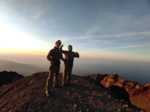
The Main Peak 3726 masl
It takes a high commitment to get here, because the heavy and sandy tracks drain the climbers’ energy quickly, not infrequently those who give up the summit halfway and return to the camp. But it is a special pride for those who make it to the top, being able to stand on the roof of Lombok Island and witness the beauty of the surrounding scenery accompanied by a sea of clouds is a valuable experience. The fastest access to get here is from the Sembalun route with 1-night camping at the Sembalun crater rim.
Second Summit 3126 Sangkareang
Mount Rinjani is not like other cone-shaped mountains in general, which only has one peak at the tip of the spear. Mount Rinjani is more precisely shaped like a cone that is cut horizontally in half and then there are many peaks on each side of the cut. One of them is the peak of Sangkareang which is the second-highest peak of Mount Rinjani.
Unlike the path to the main peak which is sandy, the hiking trail to the second peak is not too difficult to pass, where the track is still solid ground. The fastest and shortest access to get here is from the Senaru crater which starts from the Senaru hiking trail.
The view that is offered from this place is no less interesting than the main peak because you can see the view of Lake Segara Anak as a whole with Mount Baru Jari in the middle. besides that, you can also see the scenery around the island of Lombok and Mount Agung in Bali
Segara Anak Lake
Segara Anak Lake is the crater of Mount Rinjani which lies at an altitude of 2000 meters above sea level. The name Segara Anak itself comes from the Sasak language which means a mini version of the sea.
The view of this crater lake can be enjoyed from all around the crater rim of Mount Rinjani but to visit this place, climbers need at least 3 days and 2 nights.
Lake Segara Anak is usually used as a place to relax, camp, and do fishing activities because there are many types of freshwater fish.
Apart from that, it’s also a holy place for Hindus. They climb Mount Rinjani to perform religious rituals at Segara Anak Lake because it is believed to be a source of holy water.
Mount Baru Jari
Based on its name, Gunung Baru Jari means a new mountain that just appeared. Told in ancient times, Mount Rinjani named Samalas which is conical and has a height of about 5000 meters above sea level. but after experiencing a violent eruption, where at that time the eruption removed almost half of its height to 3726 meters above sea level, a crater was formed in the middle called Segara Anak and a new small volcano appeared which is still active today and can erupt at any time, the last time it was recorded the volcanic activity of this new mountain in 2016.
The height of Mount Baru Jari is 2376 meters above sea level, but if measured from the surface, it is only 376 meters high because it lies above an altitude of 2000 meters above sea level. The view of this mountain can only be seen from the summit and the crater rim of Mount Rinjani
Hotsprings
Hot springs are one of the main attractions of Mount Rinjani which must be visited, the location is not far from Lake Segara Anak, about 10 minutes walk. This hot spring comes out of the crater of Mount Rinjani and contains sulfur which is believed to cure several types of skin diseases. Hikers usually soak and relax here, this is very effective for relaxing muscles that feel stiff during the climb.
This hot spring also has several levels, where the top feels hotter than the bottom. for this reason, climbers should be careful and not just bathe here.
Tropical Rain Forest
Stretching out from the main gate of Mount Rinjani National Park in Senaru village (601 masl), an exotic tropical rainforest welcomes you to the wilderness of nature in where a variety of plants and animals live peacefully. The paths that lead to the crater rim seem to be filled with the shade of the trees and the sounds of the various birds. In addition, there are two types of apes that can easily be seen called Pitu and Makake.
rinjani trekking map


